Where do your ideas for cycling adventures begin?
I imagine, like me, you have a concept for a themed trip or a particular place, before picking up map(s) of the region and highlighting the most intriguing routes and points of interest? This time was different. After randomly finding two amazing old OS Second Series maps in a Hay-on-Wye antique shop, I lost myself in their place names, their rugged coastlines and, especially, the one intriguing track winding its way across them. I needed to escape there on the bike…
I’m a map hoarder. I’d aim for a collection like the Royal Geographic Society’s, but with only 32sqm of floor-space to play with I’ll keep finding a place for them on the over-stacked shelf, just above the over-stacked collection of bikes. The reason I have so many maps isn’t just because I enjoy seeking out enticing roads to ride and places to discover off the bike, but because I will always pick one up of everywhere I go (or plan to go, one day). For two reasons: to better understand the route and surroundings, and a deep-rooted fear of missing out on the special places or tracks you can only spot on a 1:50,000 map. Let’s call it semi-preparation, as you never want to plan all the fun out of a journey.
When I was young, getting the map out was a real ‘dad’ thing to do – “what road did you take?” or “how high were we when we stopped for those soggy egg sandwiches that time?” But now, a healthy map collection is key for travelling by bike – used, annotated and highlighted maps serve as a personalised record of bike journeys to date while, more importantly, the many others serve as inspiration for future escape routes; you never know when you might need a map of the arse-end-of-nowhere
on the shelf for when the wanderlust kicks in. Now I am convinced that getting lost in a map marks the beginning of a cycling adventure: planning a route; checking out the terrain and topography; seeking potential overnight camping spots, settlements to restock supplies, and any particular details like ferry crossings. Digital maps aren’t the same; I struggle to get lost in a digital map. They are useful for navigating on the road, but for researching and plotting a route? I need to see the bigger picture, the context. Plotting the best escape route through the Yorkshire Dales, for example, and constantly zooming in and out to find the smaller tracks amongst the network of interconnecting dales and roads makes for a super tedious experience.
When I look to escape by bike, I like to push it and head out of my comfort zone, but that is not everyone’s cup of tea. I also don’t feel the urge to travel to the other side of the world to escape, but that is the cup of choice for many. Whatever tea you’re drinking, a map is the ultimate device for escape. The wheels start rolling once the map(s) are spread over a table* and the visualising of your escape route begins.
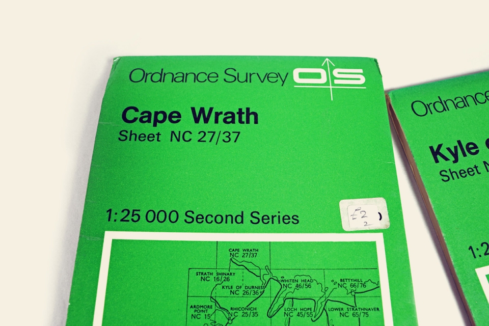
I was ready for a quick break in Hay-on-Wye, having just ridden Gospel Pass in the midst of an overnight tour through the Black Mountains. The ‘town of books’ and its myriad of independent cafes and quirky shops to explore makes for a perfect touring stop-off. Given the imminent contour crossing, I could have done without added cargo, but when I stumbled across those two old 1971-75 OS Second Series 1:25,000 maps** on a dusty shelf of the antique shop I had to make an exception; I had to have the two maps. They weren’t just any old maps, they were the two most north-westerly sheets of the UK: Cape Wrath and Kyle of Durness (Sheet NC 27/37 and 26/36 respectively) which handily sat together, plotting the 18km track to the most north-westerly point of Scotland and her remote, wild surrounds. So, into the panniers they went.
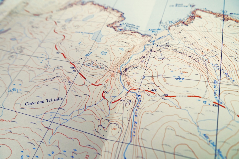
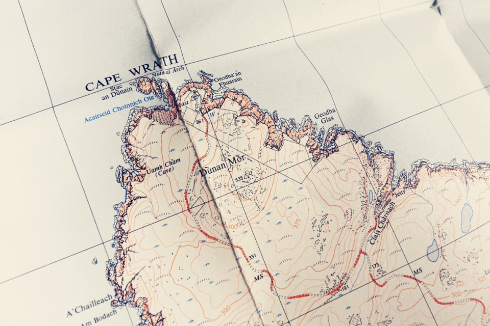
In the early 1970’s, these OS Second Series maps were formalised into 20km x 10km sheets, making a collection of 1,400-ish that covered the UK. At 1:25,000 these maps were “of great value to walkers, cyclists…and others who require maps for the study of the countryside in more detail”. As maps go, they are beautiful; it is all too easy to get lost in their detail. I was inspired, and eager to escape and ride the contour-bound track: crossing the Kearvig river; finding the jetty at Clais Charnach and brewing a coffee on the rugged coastline; wild camping by Loch na Seamraig; maybe ditching the bikes to climb up to the 535m summit of Dùnan Mòr.
From an idea of a route, it is then a case of working backwards: checking distances, terrain, and time expectations; deciding when the best time of year to go is; planning how to get to x and back from y; deciding what bike setup and touring kit will be best for the terrain; deciding whether to plan any off-the-bike pursuits and what gear that adds to the kitlist; scouting where might be good to stop each evening; and the plan b’s. The best bike journeys are simple; not easy, but simple. I have convinced Will from Brother Cycles to join me in May 2016, and what we have planned from these two old maps is a perfect example: we are going to head up to north Scotland on the sleeper train, ride the track, head south on the Cape Wrath trail, before riding back east to catch the sleeper train home. These maps marked the beginning of our latest adventure plans.
The unknown, the real escape, then lies on the road ahead: the people you meet; the landscapes; meal times and evening socialising, all at the mercy of the weather. Ultimately, you should only plan so much because things rarely go 100% to plan on a cycle tour. We call it Plan B Touring, and it is the beauty of travelling unsupported by bike – with a map and loaded touring bike as tools, you have all the freedom you could ever need. Escape is about freedom after all. The only critical things that could really stump us on this trip to north-west Scotland are the ferry crossing across the Kyle of Durness, and any military training action at Cape Wrath***.
The unknown is what we are looking forward to on this next Pannier adventure – we’ll have to see what The Cape and her wild surrounds throw our way. One thing is for sure; we’ll definitely have the two old maps to hand.
See you on the road...
NOTES.
*Escape Planning Tools:
– big table or floor;
– map(s) – preferably 1:50,000;
– highlighter;
– sketchbook;
– coffee
** The “Second Series” maps were later rebranded to Pathfinder, and have now been superseded by the OS Explorer series, still at 1:25,000.
*** A large amount of land around Cape Wrath is owned by the MOD. “The Range forms part of an area that is often referred to as the last great wilderness…its remote location and difficult & challenging terrain combined with weather conditions that can be extremely fierce make an excellent environment to test someone’s ability to survive.”